A hurricane watch and warnings of storm surges up to 15 feet high were issued Tuesday for almost all of Florida’s western coastline as Tropical Storm Helene formed over the Caribbean Sea, and heads towards the Gulf Coast.
Helene, previously called Potential Tropical Cyclone Nine, officially formed Tuesday, the National Hurricane Center said in an 11 a.m. advisory. The storm is forecast to strengthen into a hurricane Wednesday and authorities are urging people to prepare and exercise caution.
The hurricane watch extends from Indian Pass in north-west Florida near Panama City, down to Englewood, and includes Tampa Bay.
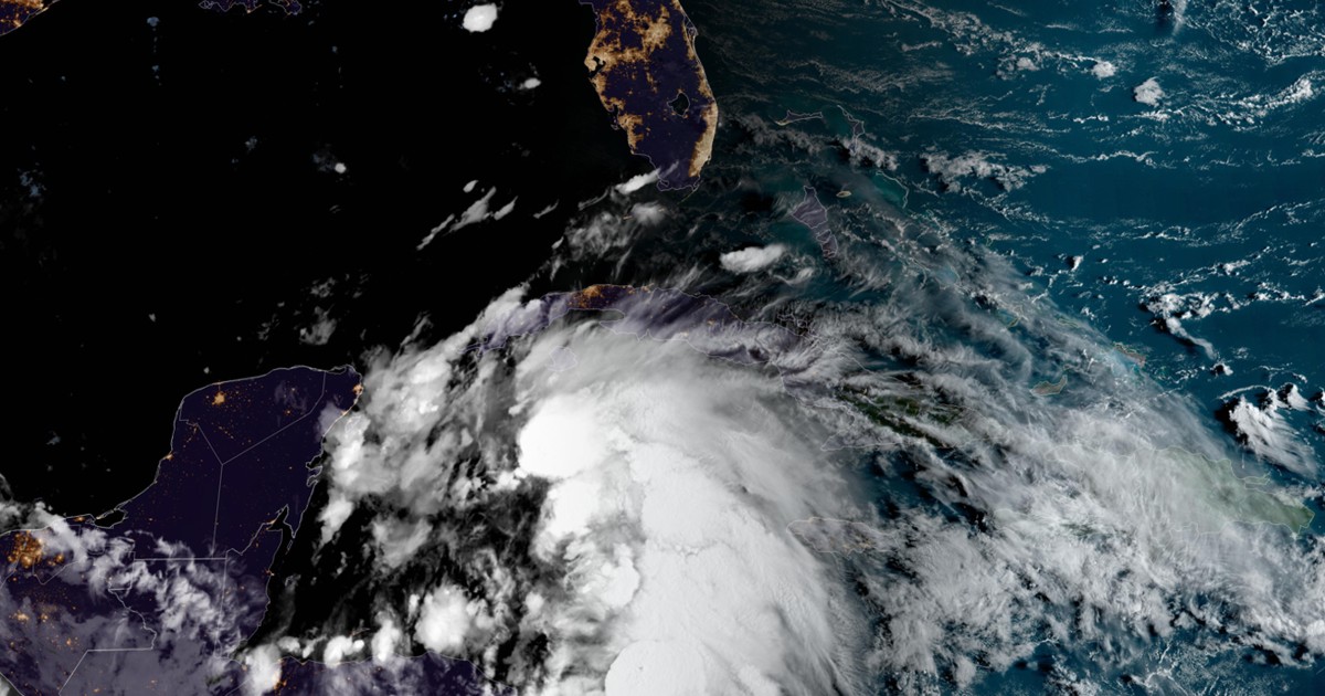
At 2 p.m. ET the weather system was about 175 miles east, southeast of Cozumel, Mexico, with maximum sustained winds of 45 mph. It’s moving northwest at 12 mph, according to the National Hurricane Center.
If it further upgrades, it’ll be the fourth hurricane to hit the U.S. this year.
The center of the storm is forecast to move across the northwestern Caribbean Sea through Tuesday night and over the eastern Gulf of Mexico on Wednesday and Thursday, the NHC said.
It could potentially reach the Gulf Coast of Florida by Thursday. Helene could become a major hurricane, meaning a Category 3 (with 111 – 129 mph winds) or higher, by then.
Hurricane and tropical storm watches are now in effect for the entire western coast of the Sunshine State.
A storm surge watch has also been issued from Indian Pass Florida southward to Flamingo, on the tip of the Florida peninsula.
A hurricane watch means that hurricane conditions are possible, and is typically issued 48 hours before the anticipated onslaught of tropical-storm-force winds and conditions.
A tropical storm watch is in place from Indian Pass to the Walton-Bay County line and from north of Bonita Beach to south of Englewood, as well as for the Lower and Middle Florida Keys.
A tropical storm warning was also issued Tuesday for the Lower Florida Keys west of the Seven Mile Bridge and for the Dry Tortugas. A tropical storm warning means that conditions are expected in the area within the next 36 hours.
Outside of the U.S., a hurricane watch is also in effect for parts of eastern Mexico from Cabo Catoche to Tulum and Pinar del Río in Cuba.
Helene is forecast to produce four to eight inches of rain over western Cuba and the Cayman Islands, with isolated totals around 12 inches. In the southeastern U.S., it’s forecast to produce three to six inches of rain with isolated totals around 10 inches, and will likely result in local flash and urban flooding. It’s also forecast to bring storm surge and strong tide, leading to flooding by rising waters moving inland from the shoreline, the NHC said.
Florida Gov. Ron DeSantis declared a state of emergency in 41 counties Monday, which was expanded to include 61 counties Tuesday. Sandbags were being distributed to residents in Tallahassee, Gulfport and Henrico County ahead of potential flooding.
DeSantis said he requested a pre-landfall emergency declaration from the Federal Emergency Management Agency. The governor warned that prediction models range from showing the disturbance forming into a tropical storm, and others show it exploding into a possible Category 4 Major Hurricane.
Models show the Big Bend and Panhandle areas should brace for potential direct impact, he said.
He urged Floridians to prepare by filling gas tanks, stocking up on food, cleaning up yards to prevent strong winds from throwing debris and to be familiar with evacuation zones. So far, 18,000 linemen are ready to restore power, 3,000 National Guard soldiers stand ready to assist and the Florida State Guard has also been activated, along with shallow water vessels and search and rescue crews.
Florida A&M University announced classes will be cancelled Tuesday afternoon through Friday due to the storm. Tallahassee State College also cancelled classes and said campuses would be closed Wednesday through Friday. Meanwhile Florida State University said campus will be closed Wednesday through Sunday. Hillsborough County Public Schools, located in the Tampa area, also announced schools will be closed Wednesday and Thursday due to the storm.
On the southeastern Gulf Coast, Sarasota County, Charlotte County, and the City of St. Petersburg all declared local states of emergency.
The Sarasota County Government said it’ll send out an evacuation alert for certain communities and manufactured home communities starting Wednesday morning. Charlotte County said evacuations have been ordered for barrier islands, low-lying and flood-prone areas, manufactured homes and residences that can’t withstand powerful winds. The City of St. Petersburg said mandatory evacuations were issued in Pinellas County for healthcare and long-term care facilities located in certain zones.
Hernando County, north of the Tampa Bay, also called for mandatory evacuations for areas west of US-19 starting Wednesday morning.
Tampa General Hospital, which has the region’s only Level I Trauma Center, began installing an AquaFence, set to be fully in place by Wednesday. The fence provides “a water-tight barrier capable of withstanding up to 15 feet of storm surge to protect vulnerable areas of the hospital,” the hospital wrote on Facebook.
The National Oceanic and Atmospheric Administration predicted an extremely active hurricane season forecasting 17 to 24 named storms, eight to 13 of which could become hurricanes, including four to seven major hurricanes.
The hurricane season runs from June 1 through November 30. The reasons for the high activity include warmer than average sea surface temperatures in the tropical Atlantic and Caribbean sea, reduced vertical wind shear, weaker tropical Atlantic trade winds and an enhanced west African monsoon.
In the case of Helene, record warm waters will fuel the intensification of the disturbance. According to Climate Central, exceptionally warm sea surface temperatures along the system’s projected path, through the Northern Caribbean and Eastern Gulf of Mexico, have been made at least 200 to 500 times more likely due to human-caused climate change. Rapidly intensifying hurricanes are becoming more common in the warmer world.
The three last hurricanes to hit the U.S. were Beryl which made landfall in Texas in June, Debby which made landfall in Florida’s Big Bend region and again in South Carolina in August, and Francine, which made landfall in Louisiana on Sept. 11.
If Helene does become a hurricane, it’ll be the fifth hurricane to make landfall on Florida in three years, according to the Florida Climate Center.